
|
|
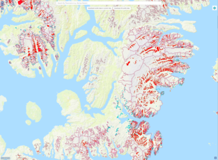
The GLIMS Glacier Viewer is an interactive map which gives a view of data in the GLIMS Glacier Database. A number of different layers in this interface can be viewed and spatially queried including: GLIMS Glacier Outlines, other glacier databases such as the World Glacier Inventory, Regional Coordinator Locations, and others. The GLIMS Glacier Outlines layer contains the results of glacier mapping within the GLIMS initiative. Each polygon in this layer represents the extent of a particular glacier at a specific time, as well as other possible features of the glacier such as the extent of debris cover or the location of supra-glacial and pro-glacial lakes. The GLIMS Glacier outlines can be downloaded as ESRI Shapefiles, MapInfo tables, Geographic Mark-up Language (GML) files, Keyhole Mark-up Language (KML, Google Earth), and the Generic Mapping Tools (GMT) multi-segment format.
Drag to pan the map. Use the mouse wheel, zoom-controls, or pinch gestures (on a tablet or phone) to zoom. Hold shift and drag a box to zoom to a region. Single-click to query visible layers.
Use the GLIMS Glacier Viewer.
This interface provides access to the GLIMS Glacier Database through a text-based search form. The parameters one can search on, as well as the result fields that can returned, are customizable. This allows the user to search on and return only the criteria that are relevant to their needs. Query results in this interface can be downloaded individually or as part of the larger result set. Downloaded data are available in the same formats as from the map-based interface (above).
Use the GLIMS Text Search.
Another way of accessing data within the GLIMS Glacier Database is through the Open Geospatial Consortium's (OGC) Web Map Service (WMS) and Web Feature Service (WFS) protocols. These services allow access to GLIMS Glacier data directly from desktop GIS software products such as QGIS, ArcGIS, GRASS, or Google Earth, as well as other applications such as MapServer.
To access data layers via WMS from a client such as QGIS, enter
https://www.glims.org/geoserver/ows?service=wms&version=1.3.0&request=GetCapabilities
as the URL for the layer.
The information returned by the GetCapabilities request allows the client to display the all the layers available in the GLIMS system, which includes many
GTN-G data sets, such as (not exhaustive list):
If you have any comments on the data in the GLIMS Glacier Database, please send them to